

On whitewater raft trips, many sections of the Klamath River rumble through walls of frothing whitewater.
But from above the river looks benign, just a tiny thread of water passing through a fractured canyon carved over eons of geologic upheaval.
Five of us were watching from hundreds of feet above, including Bruce Gordon who was flying the small Cessna airplane along and over the Klamath River, tracing its winding path from Klamath Falls to far northern California. Sponsored by the Klamath River Renewal Corporation (KRRC), the purpose of the flight was to offer birds-eye views of the river and four dams slated for removal in coming years, possibly in 2024.
“You get to see so many parts of the landscape from an airplane that you can’t see by driving a vehicle,” said Gwen Santos, the senior wetlands engineer for Resource Environmental Solutions (Res), an environmental mitigation company that will work to restore areas and natural resources impacted by removing the dams.
Four PacifiCorps dams — the J.C. Boyle, Copco No. 1 and No. 2, and Iron Gate — are scheduled to be removed as part of a controversial effort that advocates have said will restore the health of the river, fish and communities along the river, including several in the Upper Klamath Basin.
Dam removal is something that has drawn heated discussion for and against for decades, highlighted in 2001 when decisions to not release water to Klamath Basin irrigators resulted in protests and demonstrations that drew national attention. This year only minimal amounts of irrigation water are scheduled to be released but the Klamath Tribes, citing concerns for two endangered sucker fish, have filed suit to prevent any release of water from Upper Klamath Lake.
The purpose of the flight, as with orientation flights periodically offered through EcoFlight, is to allow people to view landscapes impacted by environmental actions.
“My mission,” said Gordon, who is a pilot and an EcoFlight founder, “is to get the word out and inspire people to educate themselves. We’re an educational outfit. We want people to look at the dams, learn about where they are [in the larger landscape], and advocate from an educated aspect, no matter what position they take.”
Among the passengers was Toz Soto, the lead fish biologist with the Karuk Tribe. He is an advocate for removing the dams, quietly but firmly insisting dam removal will restore and strengthen salmon and steelhead habitat.
“It’s a really unique environment,” Soto said of the Klamath River and its ecosystem, noting it originates from the Williamson, Sprague and other rivers that feed into Upper Klamath Lake, which funnels into the Link River and Lake Ewauna, ending 263 miles in the Pacific Ocean.
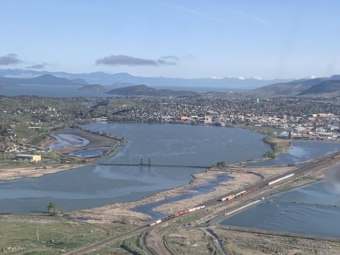
Quietly but busily observing the sights was Jason Jaacks, a freelance photojournalist shooting film and video for Jefferson Public Radio. From his and other window seats, most of the Klamath seems to wriggle snake-like through a mixed landscape. From its beginning in Klamath Falls, it passes Columbia Forest Products on its way to Keno and the Keno Dam, which is not scheduled for removal.
Past Keno the river runs wild until it stalls at the reservoir formed by the John C. Boyle Dam. It resumes weaving downstream, stalled into reservoirs created by the Iron Gate, Copco 1 and Copco 2 dams. From above, the Iron Gate Dam is alongside powerhouses and spillways. Originally built to generate power — and statistics indicate that the power the dams generate is minimal — none of the four have fish ladders, which has blocked Coho salmon and spring and fall chinook from migrating upriver to Upper Klamath Lake.
From above, the river mostly appears as a thread through a landscape that is at times surrounded by pockets of trees and at others by thick expanses of dense forest. The riverside clearings are mostly at dam sites, with most accessed by zig-zag dirt roads. But in an airplane, the most dominating feature is massive Mount Shasta, seemingly even larger because it is still-sprawling blanket of snow drapes far below its 14,179-foot summit. Other landmarks, such as Pilot Rock and Mount McLoughlin, likewise poke above the trees.
Our focus, and the purpose of the flight, was observing the river and its dams. How, the inevitable thought is, might the landscape look if and when the dams are removed.
Soto and Santos exude optimism, confident that the years of study and preparation will help an admittedly complex rehabilitation process. Santos noted that more than 11 billion seeds already have been collected for replanting along with containerized plants, including various shrubs, Oregon ash and elderberries. Soto believes a free-flowing river will significantly improve fish passage and water quality, explaining the river and the land it weaves through is unique because the water originates from freshwater springs.
Returning to Klamath Falls too soon, the plane passed over farmlands flanking the river, revealing large irrigated blocks of green alongside other blocks of unirrigated brown fields.
Flying above the Klamath River truly adds a new perspective, a sense of the broad scope of the region now impacted by the dams and, when they are removed, what comes next.